mediaTUM
Universitätsbibliothek
Technische Universität München
User: Guest
Login
de
en
Advanced search
mediaTUM Content
University Bibliography
Electronic Examination Papers
Open Access Publikationen
Research Data
TUM.University Press
Collections
Architekturmuseum - Collection
Agricultural Technology digital
AgTecCollection - Images and Documents Agricultural Engineering
Images
Agricultural Systems Technology - Technische Universität München
(54064)
Labour economics
(2877)
Soil cultivation
(2885)
Energy technology
(743)
Harvesting technology
(6812)
Vehicles
(2663)
Research and education
(562)
Forest technology
(70)
Horticultural technology
(4120)
Buildings and structural facilities
(6469)
Information technology
(2081)
Digitalization
(3)
Management
(12)
Standardization
(337)
Location sensing and navigation
(311)
Global positioning system
(237)
Location sensing
(67)
Navigation
(4)
Instrument display
(113)
Performance monitor
(301)
Data acquisition
(160)
Data processing
(329)
Ducumentation
(86)
Feeding computer
(32)
Personal digital assistant (PDA)
Ventilation computer
(3)
Terminal
(53)
Electronics
(139)
Weather station
(75)
Electronic stall panel
(1)
Guidance systems
(24)
Image analyses and processing
(59)
Land administration
(1028)
Machinery technology
(5819)
Promiculture engineering
(379)
Economics
(1055)
Plant production technology
(9037)
Plant protection technology
(597)
Animal production technology
(7200)
Environment technology
(355)
Viticultural technology
(172)
Agricultural Systems Engineering - Humboldt Universität Berlin
(5232)
Documents
Movies, Videos, Voice Recordings
Research Data
Chair of Agricultural Systems Engineering
Agrimechatronics
ATB-Collection
Image Collections
Projects
Institutions
mediaTUM Gesamtbestand
Sammlungen
Agrartechnik digital
AgTecCollection - Bilder und Schriften Landtechnik
Bilder
Landtechnik - Technische Universität München
Informationstechnik
Ortung und Navigation
Globales Positionierungssystem (GPS)
002196.png
Available image formats
image/png (66.4 kB)
Dokumenttyp:
Diagramm
Titel:
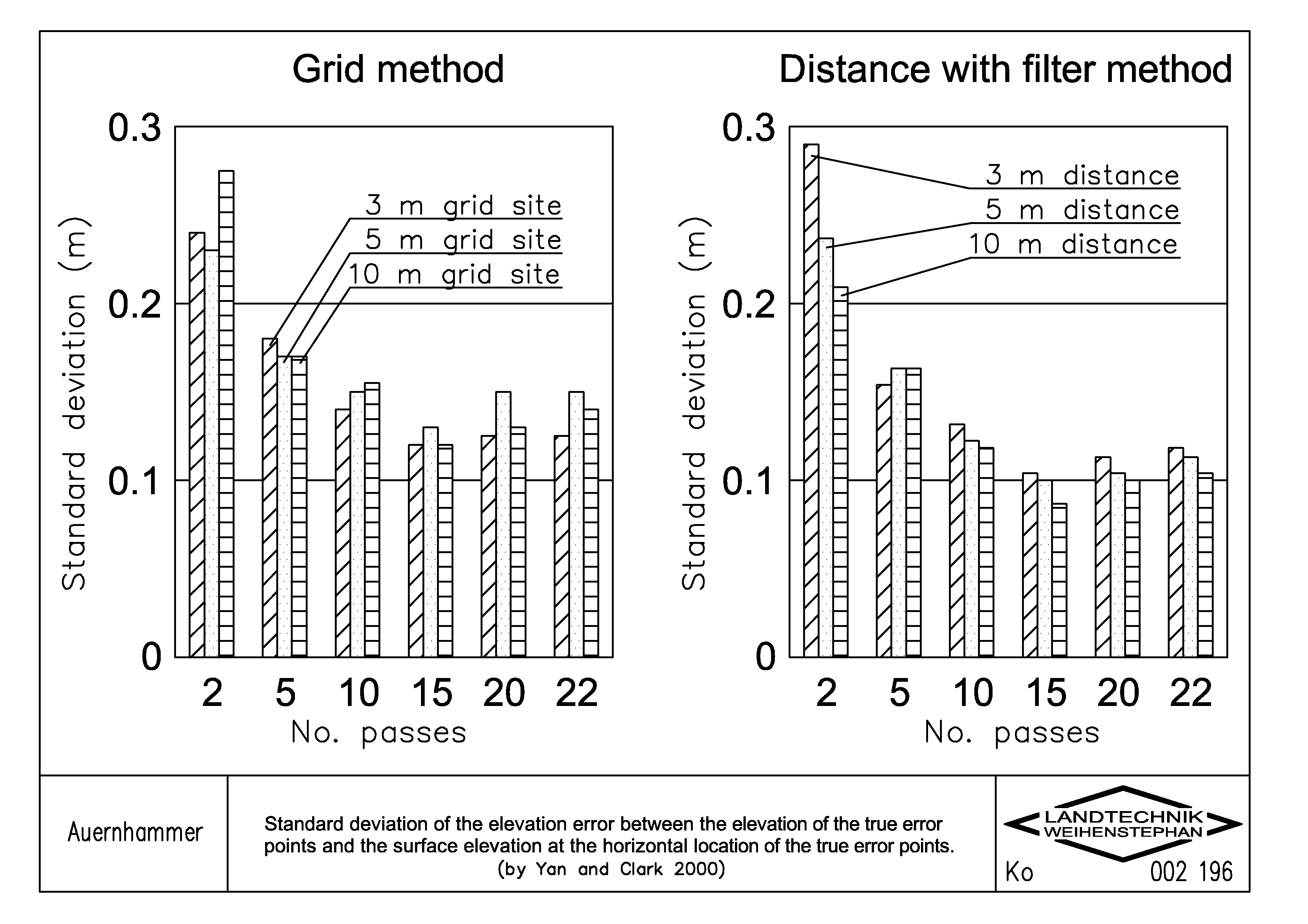
Standard deviation of the elevation error between the elevation of the true error points and the surface elevation at the horizontal location of the true error points (by Yan and Clark, 2000)
Schlagworte:
Sensortechnik; Globales Positionierungssystem (GNSS)
Schlagworte (engl.):
Sensor technology; Global Navigation Satellite System (GNSS)
Autor/en:
Auernhammer, H.
Jahr:
2000
Genaues Erstellungsdatum:
08.12.2000
Sprache:
en
Farbe:
schwarzweiß
Hinweise:
dwg File in Attachment
Zeichner:
Kolbinger, S.
Herkunft:
Institut für Landtechnik TUM / Zeichenbüro
Erfassungsjahr:
2009
Zitation:
http://mediatum.ub.tum.de/export/733326/citation
Open attachment browser...
Occurrences:
mediaTUM Gesamtbestand
Sammlungen
Agrartechnik digital
AgTecCollection - Bilder und Schriften Landtechnik
Bilder
Landtechnik - Technische Universität München
Informationstechnik
Ortung und Navigation
Globales Positionierungssystem (GPS)