mediaTUM
Universitätsbibliothek
Technische Universität München
Benutzer: Gast
Login
de
en
Erweiterte Suche
mediaTUM Gesamtbestand
Hochschulbibliographie
Elektronische Prüfungsarbeiten
Open Access Publikationen
Forschungsdaten
TUM.University Press
Sammlungen
Architekturmuseum - Sammlung
Agrartechnik digital
AgTecCollection - Bilder und Schriften Landtechnik
Bilder
Landtechnik - Technische Universität München
(54064)
Arbeitswirtschaft
(2877)
Bodenbearbeitungstechnik
(2885)
Energietechnik
(743)
Erntetechnik
(6812)
Fahrzeuge
(2663)
Forschung und Lehre
(562)
Forsttechnik
(70)
Gartenbautechnik
(4120)
Gebäude und bauliche Anlagen
(6469)
Informationstechnik
(2081)
Digitalisierung
(3)
Management
(12)
Normung
(337)
Ortung und Navigation
(311)
Bordinstrumente
(113)
Bordcomputer
(301)
Datenerfassung
(160)
Datenverarbeitung
(329)
Dokumentation
(86)
Fütterungscomputer
(32)
Personal Digital Assistant (PDA)
Stallklimacomputer
(3)
Terminal
(53)
Elektronik
(139)
Wetterstation
(75)
Elektronische Stalltafel
(1)
Spurführungssysteme
(24)
Bildanalyse & Bildverarbeitung
(59)
Landbewirtschaftung
(1028)
Maschinentechnik
(5819)
Obstbautechnik
(379)
Ökonomie
(1055)
Pflanzenanbautechnik
(9037)
Pflanzenschutztechnik
(597)
Tierhaltungstechnik
(7200)
Umwelttechnik
(355)
Weinbautechnik
(172)
Agrartechnik - Humboldt Universität Berlin
(5232)
Schriften
Filme & Videos
Forschungsdaten
Lehrstuhl für Agrarsystemtechnik
Lehrstuhl für Agrarmechatronik
ATB-Collection
Bild-Sammlungen
Projekte
Einrichtungen
mediaTUM Gesamtbestand
Sammlungen
Agrartechnik digital
AgTecCollection - Bilder und Schriften Landtechnik
Bilder
Landtechnik - Technische Universität München
Informationstechnik
Dokumentation
Zurück
Zurück zum Anfang der Trefferliste
Dauerhafter Link zum angezeigten Objekt
Verfügbare Bildformate
image/png (114.0 kB)
Dokumenttyp:
Kartierung
Titel:
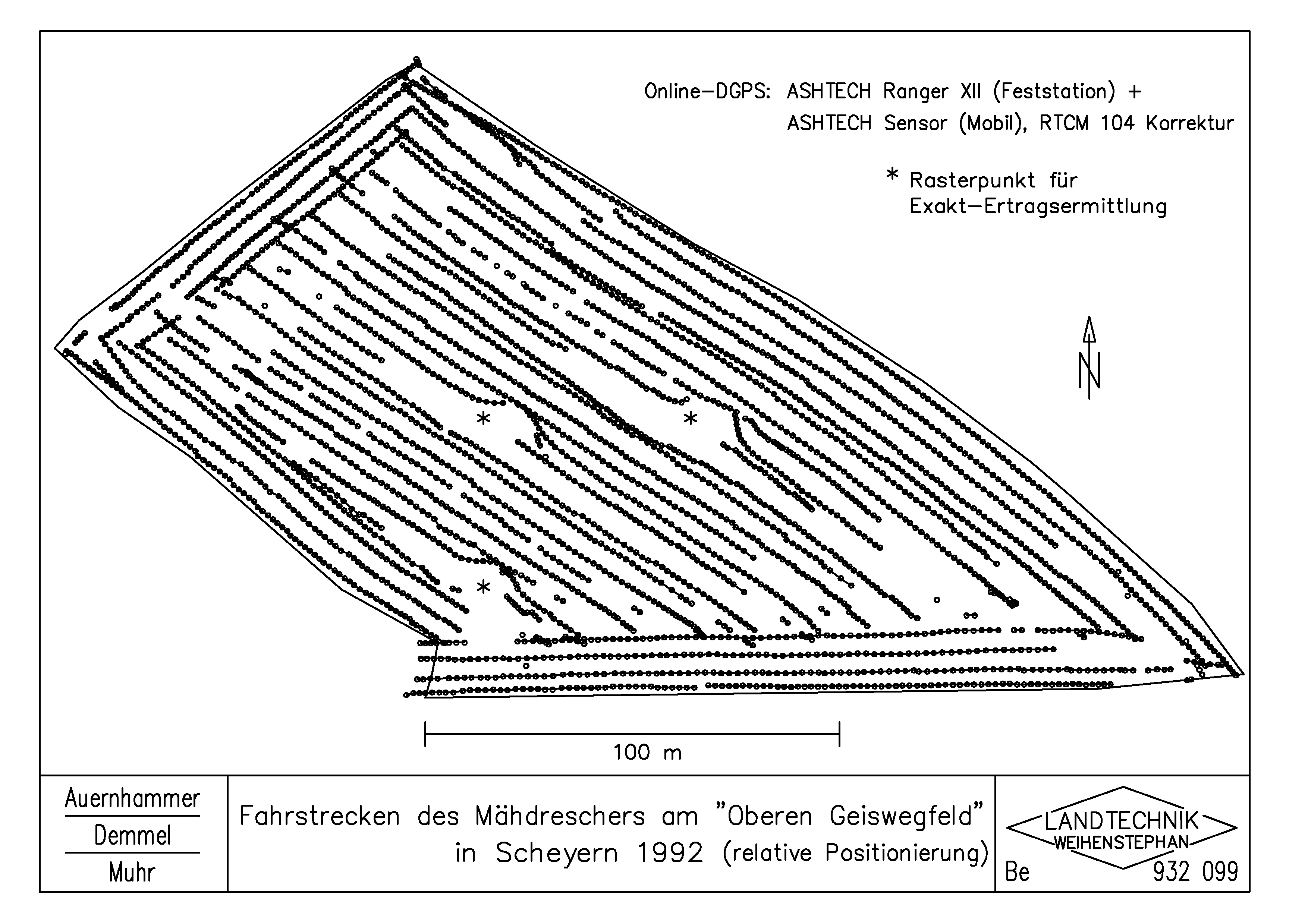
Fahrstrecken des Mähdreschers am "Oberen Geiswegfeld" in Scheyern 1992 (relative Positionierung)
Schlagworte:
Informationstechnik; Sensortechnik; Mähdrescher selbstfahrend; Globales Positionierungssystem (GNSS); Dokumentation
Schlagworte (engl.):
Information technology; Sensor technology; Self-propelled combine harvester; Global Navigation Satellite System (GNSS); Ducumentation
Autor/en:
Auernhammer, H.; Demmel, M.; Muhr, T.
Jahr:
1993
Genaues Erstellungsdatum:
31.03.1993
Sprache:
de
Farbe:
schwarzweiß
Hinweise:
dwg File in Attachment
Thema:
Tramlines
Zeichner:
Berchtold, M.
Herkunft:
Institut für Landtechnik TUM / Zeichenbüro
Erfassungsjahr:
2004
Zitation:
http://mediatum.ub.tum.de/export/709500/citation
Attachment-Browser öffnen...
Vorkommen:
mediaTUM Gesamtbestand
Sammlungen
Agrartechnik digital
AgTecCollection - Bilder und Schriften Landtechnik
Bilder
Landtechnik - Technische Universität München
Informationstechnik
Dokumentation